TrailDamage.com

Photos, videos and information about 4x4 trails in Colorado and Utah

  • Trails
    • Colorado
    • Utah
  • Reports
    • Featured Photos
    • Featured Videos
    • Reports Calendar
  • Members
  • Search
  • Trail Damage Winners
  • FAQ
  • Community
  • Upcoming Events
  • Membership
  • Log In
  • Facebook
  • Instagram
  • RSS
  • Twitter
  • YouTube

Hidden Canyon Overlook 070517

May 17, 2007 by Monica

Hidden Canyon Overlook

Trail Run on May 17, 2007
Report and photos by Monica I., Trail Leader
View trail information for Hidden Canyon Overlook

Walt S.
Gray 2018 Jeep Wrangler Unlimited Rubicon
Michael M.
Black 2006 Jeep Wrangler Unlimited Rubicon
Monica I.
Red 2010 Jeep Wrangler Rubicon

We finished our day of many trails with Hidden Canyon Overlook, and it ended up being one of the best trails. It got very confusing in spots, but we eventually made our way through it. It would have been very difficult to do without a GPS and some waypoints.

We ended up doing it backwards, which made the big, red hill much easier (it was downhill instead of uphill). We did Bartlett Overlook first, and then we made our way to the Hidden Canyon Overlook.

We found the huge cairn and made a couple wrong turns. Our trail choices ended so we had to keep coming back until we found the right one. It was the most traveled one.

The big, red hill was pretty steep and narrow. It reminded us of Red Cone back in Colorado (though a much smaller version). It was difficult to see where you were going, and the dirt was very loose. It would definitely be difficult going up.

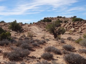
After that, we all got out and wandered around the slickrock hill, searching for the trail. We could see the trail we wanted to get to, but we weren't sure how to get down the slickrock hill. We finally found it and worked our way down. There were options, and we took the easiest one.

After that, the trail was easy to find. We got to the intersection and turned right to go check out the overlook. It was really gorgeous, and it was cool to see the trail we'd be on soon.

We headed back and started doing the Hidden Canyon Overlook trail out to that trailhead. It went across big sections of slickrock and it would be really difficult to find if you were new to Moab trail finding. If it was dark or raining it would be very, very difficult to find.

When we got to the intersection with Lunar Canyon there was a row of white sand bags there. It was very bizarre. We decided to try to find our way through Lunar Canyon, so we turned left there. It was difficult to find, but no more difficult that route finding had been so far. It was worth the bypass. The terrain was definitely weird.

When we got back, we turned right to go back to the sand bags and the initial intersection with Lunar Canyon. That way we could see the whole trail. When we got back to the intersection we turned around and backtracked. Then we went through the gate and headed back out to the trailhead.

When we got out we finished up the rest of Hidden Canyon. It was a great day filled with lots of scenery and challenges.

after_the_big_red_hill
big_red_hill_part_1
big_red_hill_part_2
checking_out_the_slickrock_hill
cloudy
dirt_climb
following_cairns
huge_cairn
long_road
lunar_canyon_part_1
lunar_canyon_part_2
lunar_canyon_part_3
lunar_canyon_part_4
lunar_canyon_part_5
lunar_canyon_part_6
lunar_canyon_part_7
lunar_canyon_part_8
michael_at_the_overlook
michael_down_the_big_red_hill
monica_at_the_overlook
monica_down_the_big_red_hill
overlook_part_1
overlook_part_2
overlook_part_3
overlook_part_4
overlook_part_5
sand_bags
slickrock_and_sand
trail_on_slickrock_part_1
trail_on_slickrock_part_2
walt_and_michael_down_the_big_red_hill
walt_and_michael_down_the_slickrock_hill
walt_at_the_overlook
walt_down_the_big_red_hill
weird_things_in_a_rock

Reports from Other Days: 2

Use the arrows or dots to flip through the previews of the other reports for Hidden Canyon Overlook. Click one of them to read more and see all of the photos from that day.

October 20, 2012

Led by Monica I.
We came out of Hidden Canyon and turned north to get up to the views above the canyon. We followed our track from 2007 but it was fenced off and closed to 4×4 vehicles, so we found another way in. It didn’t take us too long to find the way,…
«
  • 1
  • 2
Join Us!
If you aren’t a Member or Subscriber, you can’t see all of the content on this site. Get membership information to see why this site is best when you join and log in

Information for Subscribers

When you log in you’ll see more information here:

  • Recent Community Forum posts
  • Recent polls
  • Upcoming Events you can attend
  • Links to online users

© 2000-2022 · TrailDamage.com · Terms and Conditions · About · Contact
Trail information is only accurate on the date posted. Trails may have changed or closed since that date. Use this information for historical purposes only.
Contact the Forest Service or Bureau of Land Management for up-to-date trail information.

/* ----------------------------------------- */ /* View slug: reports-other-reports-for-same-trail-slider - start */ /* ----------------------------------------- */ /* place the prev/next controls on the sides */ .td-transition-controls .wpv-filter-next-link, .td-transition-controls .wpv-filter-previous-link { border: none; font-size: 300%; position: absolute; top: 70px; } .td-transition-controls .wpv-filter-previous-link { left: 0; } .td-transition-controls .wpv-filter-next-link { right: 0; } /* center the page selector horizonatally */ .td-transition-controls ul.wpv_pagination_dots { text-align: center; margin-top: 10px; } /* center the page selector horizonatally */ .td-transition-controls ul.wpv_pagination_dots li.wpv_pagination_dots_item, .td-transition-controls .wpv_pagination_dots li a { display: inline-block; float: none; } /* remove the default styles */ .td-transition-controls .wpv_pagination_dots li a { text-decoration: none; border-bottom: none; } .td-slider-container { padding: 0 25px; margin-bottom: 20px; position: relative; width:100%; display:table; } .td-slides { position: relative; } .td-slides-image { float:left; display:table-cell; } .td-slides-image img { border:1px solid #c0c0c0; } .td-slides-content { padding:4px 4px 4px 10px; border-top:1px solid #c0c0c0; border-right:1px solid #c0c0c0; border-bottom:1px solid #c0c0c0; display:table-cell; height:227px; overflow:hidden; } .td-slides-content h3 { margin-top:8px; } .td-slides-leader { font-size:smaller; margin-top:4px; } /* ----------------------------------------- */ /* View slug: reports-other-reports-for-same-trail-slider - end */ /* ----------------------------------------- */
/* ----------------------------------------- */ /* Content Template: Template for a Single Report - start */ /* ----------------------------------------- */ .entry-header { display:none; } .entry-content h1 { margin-top:16px; padding-top:0; } h1 a { color:#222; } h1 a:hover { color:#666; } p.entry-meta { font-size:small; } #report-body-spacer { clear:both; width:100%; height:20px; } #addtoany-bar { margin-bottom:2em; text-align:center; } .category-reports .post-info .author, .post-info .date { display: none; } .addthis_recommended_horizontal { text-align:center !important; } /* ----------------------------------------- */ /* Content Template: Template for a Single Report - end */ /* ----------------------------------------- */ /* ----------------------------------------- */ /* Content Template: Loop item in REPORTS Runners - start */ /* ----------------------------------------- */ #runners-container { width:100%; clear:both; } .runner { border:1px solid #c0c0c0; margin:0 6px 6px 0; float:left; width:49%; height:81px; } .runner-image { float: left; } .runner-image img { margin:2px 10px 0 2px; height:75px; width:75px; } .runner-name { text-transform:uppercase; } .runner-name a { color:#222; } .runner-name a:hover { color:#666; } .runner-vehicle { font-size:small; } @media only screen and (max-width: 768px) { .runner { width:100%; } } /* ----------------------------------------- */ /* Content Template: Loop item in REPORTS Runners - end */ /* ----------------------------------------- */